
Impact of the Interstate System on the America Population, 1950 – 2000

The Eisenhower Interstate System: something my generation uses consistently, but rarely ever recognizes for more than its pothole ridden, traffic filled corridors. The Interstate Highway System, championed by President Dwight D. Eisenhower, was fist authorized in 1956 through the Federal highway act, with construction of the original portion being completed 35 years later. While the economic impact of this measure is probably the first question on everyone’s mind, I would like to instead explore what kind of impact the new Interstate system had on the population of America and the amount of credit given to the Interstate System for changing the face of America.
Words, Words, Words

This first slide is a visual representation of an article from 1955 from the New York Times created through Voyant. The article, entitled Eisenhower Gets 101 Billion Federal-State Road Plan and authored by Joseph A. Loftuss (which had to be painstakingly typed out in a word document due to ProQuest’s lack of a copy paste feature) , discusses the concerns over the Interstate System right as the proposal was approved. The main focus, which is reflected in the visualization through the prevalence of the words “states” and “funds,” was the financial relationship between the state and federal governments during the time of construction. At this point, the impact on the large American population was either not considered or considered not to be of importance.
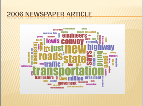
This second visualization was also made in a similar fashion, except with a 2006 New York Times Article entitled Slow Road Movement? by Robert Sullivan, which discusses how the interstate has created a sort of speed based society that is less focused on slowing down an enjoying the world around us. While there is some discussion of future funding that has seeped its way into this visualization, it is also possible to see the concern over how the Interstate System has Americans shying away from traditional roadside towns with the inclusion of the words “freedom,” “slow,” and “movement.” If you have ever seen the animated film Cars, you know exactly what I am talking about: if a place is too far off of the Interstate System, there will not be much traffic.
The Shift in American Population
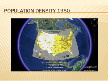
This map, found on The Federal Highway Administration’s website, is of the population density of the American population before the Interstate System was put into place. While the automatic curvature of the map due to Google Earth has skewed some of the borders, it is still easy to identify areas of dense population. The faint grey lines, which also may be hard to see, are where the interstate is planned to be built. Put into words, the interstate was to be built primarily around areas of dense population to connect to other areas of dense population, though there is a considerable amount of the American population spread out around the mid-West.
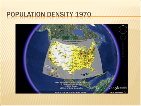
Twenty years later there has already been a noticeable shift in the density of the population, which has now begun to center around the work-in-progress Interstate System (which can now be seen as black lines). Though the initial interstate plans were structured loosely around the areas of dense population, it is now become apparent that the population is molding itself to the new Interstate System, likely out of convenience and the development of more metropolitan areas around the interstate.
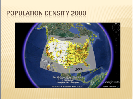
Finally, a map of population density of America from the 2000 shows the incredible shift in population density around the Interstate System. Once again, though the initial intent was to build the Interstate System in a way that would be convenient for already existing pockets of the American population, it is clear the the Interstate System soon became a sort of lattice for the American Population to cling on to.
A New Way of Life
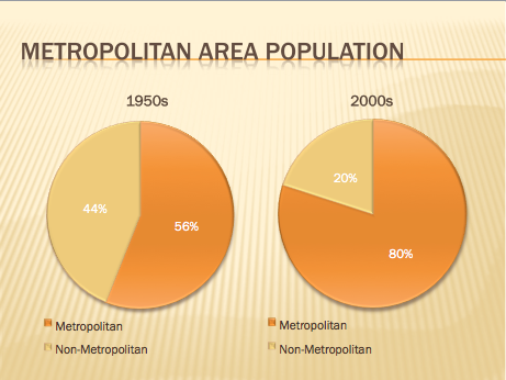
Beyond simply shifting the American population density to be centered around the interstate, the Interstate System also changed the makeup of the national population in terms of type of living environment. Before the Interstate System (according to the same website), the 56% of 1950s American population resided in metropolitan areas. Fifty years later, the national population has shifted to 80% metropolitan areas. This only further supports the previous maps in proving that the Interstate System played a vital role in forming the cities we inhabit today.
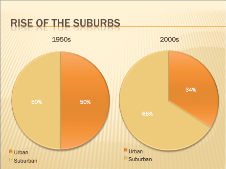
Finally, within the metropolitan areas, the Interstate System has also helped to spur on the transition into suburbs. From the 1950s to the 2000s, the percent of the Metropolitan population residing in suburban areas has jumped from 50% to 66% and is rising. Instead of having sprawling living areas, the more recent trend has been to concentrate living spaces in the areas around the Interstate System and the major cities fueled by it, which has in turn also impacted the population density as seen in the map.
Conclusion
From a combination of these maps, articles, and statistics, it is clear to see that Eisenhower’s Interstate System had a massive impact on the way Americans live. First and foremost, the Interstate System drastically shifting areas of dense population to be centered around areas where the roads formed under this system converge. Furthermore, it is also clear that this geographic shift has also had an impact on the environment in which we currently live. Overall, it is undeniable that the Eisenhower Interstate system was a major shaping force in creating the America we know today.